On the afternoon of May 7, 1995, a series of tornadoes produced significant damage (up to F3 intensity) in north-central Texas and south-central Oklahoma. Beginning the day after this event, press releases were distributed to news media along and downstream of the tornado track to alert residents to be on the lookout for transported debris. Fifty-two reports of long-range debris transport were received. (Here "long-range" refers to debris which was found greater than 8 km [5 mi] from its source.) Forty-three items were traced back to their point of origin, and trajectories outside the storm environment have been estimated using local VORTEX soundings, WSR-88D data, and fall speeds calculated from the actual debris collected.

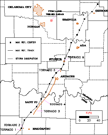
Figure 1. Tornado tracks and maximum reflectivity tracks for southern Oklahoma-northern Texas supercell, 5-7-95. Reflectivity track from composite radar images, including Oklahoma City (Twin Lakes).
The third and fourth tornadoes combined to produce a continuous damage path of 93 km (58 mi) from Texas into Oklahoma. Just north of the Texas-Oklahoma border, the fourth tornado struck the Red River RV Park and then the Falconhead resort. The tornado continued northeast into the west side of Ardmore, where it caused heavy damage to the Michelin/Uniroyal plant.
The fifth and sixth tornadoes occurred northeast of Ardmore, and each produced F1 damage. As the supercell moved into a more stable air mass in central Oklahoma, the size of the reflectivity echo decreased significantly. Visual characteristics reported by storm chasers suggested a low precipitation (LP) character in this dissipating stage. Although the majority of the reflectivity echo dissipated about 15 km northwest of Ada, a small area of weak reflectivity persisted until the storm passed Okemah.

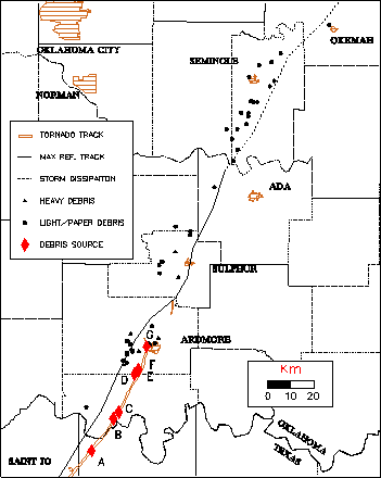
Figure 2. Debris fallout locations, reflectivity track, and sources.
Most of the debris was deposited along or within 20 km to the left of the center of the maximum reflectivity track. This is consistent with the findings of both Anderson (1985) and the historical study by Snow et al. (1995, 1996, this volume), who found that most debris falls along or to the left of the approximate "storm track" and its extrapolation downstream. All of the reported debris was deposited in locations over which the reflectivity echo was detected at some time.
One account of debris transport was associated with deposition in the near-storm environment. A photograph was transported 30 km from Falconhead and was seen falling from the sky at the time the fallout location was on the northwest side of the maximum reflectivity gradient of the storm.
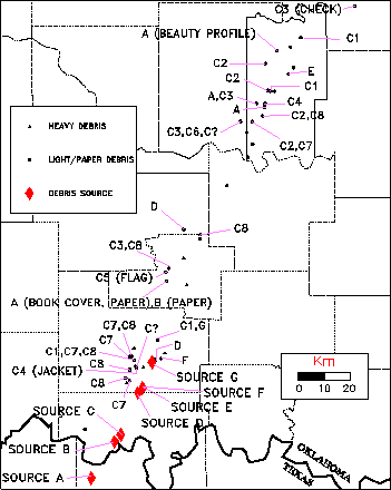
The majority of the traceable debris items came from the Falconhead resort (denoted by the letter C in Figure 2), where the tornado destroyed 20 homes, an aircraft hangar, and a maintenance building, as well as inflicting damage to 20 other homes. The corresponding debris sources for each fallout location are shown in Figure 3. Debris from eight known locations at Falconhead (C1-C8) were deposited along and to the left of the track up to 190 km (120 mi) downstream. The item that traveled 190 km was a canceled check from a Falconhead residence (C3). Several checks from another Falconhead home (C1) were scattered from 30 to 170 km downstream, indicating that similar debris lofted from the same point will not necessarily come down at the same location.

Figure 3. Debris source identification.
In many of the reports, multiple items were deposited at the same location. One piece of paper from a Falconhead residence was transported 80 km and was found with 13 other untraced items. At another location (labeled A,B in Figure 3), two pieces of paper with similar size and fall speeds came from sources 20 km apart: one from the Red River RV Park (source B) and the other from near St. Jo (source A). At the same fallout location, the much heavier cover of the textbook (also from source A) was deposited. Thus, two similar items from different sources were deposited in the same location, and two items of significantly different weight from the same source were deposited at the same location.
A personalized jacket and a golf flag (Figure 3) were among the traceable non-paper items found to have been transported from Falconhead. The jacket was found 30 km from its source in near perfect condition with no tears, holes, or major scratches. However, the 48 cm by 33 cm flag from the Falconhead golf course was torn in places and stained. The flag was transported 70 km and still contained part of a plastic rod, making it heavier than most other debris items.
Five homes not associated with the Falconhead resort were also sources of debris transport. A Mary Kay beauty profile, 14 cm by 22 cm, from source A was transported 185 km. The receipt contained two identical pages (a carbon copy) connected to a stub with perforated seals. None of the writing appeared blurred as it would if it had been severely wetted, and the weak perforations were only partially ripped. The excellent condition of some of the other checks, receipts, and photos (lack of smeared ink, tears, or holes) indicate that some, but not all, debris is lofted and transported long distances without being damaged or water-soaked.

Figure 4 under construction!
Figure 4. 18Z and 21Z Ardmore soundings.
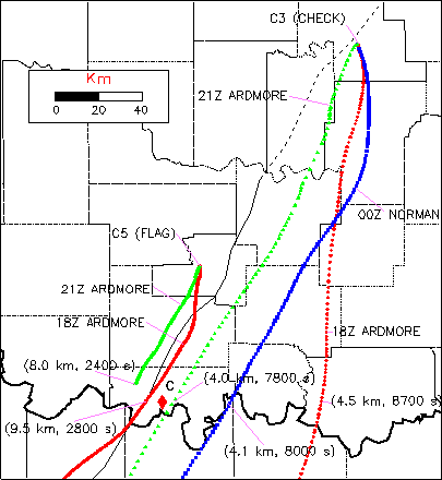
Vertical fall speeds for all the collected debris items were determined from multiple tests in still air. Values ranged from approximately 3.5 m/s for the flag and book cover to a consistent 0.5 m/s for all the checks. This verified independent work on check fall speeds by Church (1994), private correspondence). Backward trajectories for the golf flag and a check from Falconhead are shown in Figure 5. The 21 Z sounding from Ardmore (taken in the near storm environment) yielded the most realistic trajectory for the check out of the three wind profiles. Variations in the wind field in and around the storm environment have the potential to significantly affect the transport of light debris over long distances. If the check had left the storm's updraft or downdraft around 4 km, differences in the estimated fallout location of up to 70 km could result, depending upon the sounding used. Total transport times for the check can be over two hours.

Figure 5. Estimated backward trajectories for two items using Ardmore 18Z, 21Z, and Oklahoma City 00Z soundings. Height of debris at source distance and total time in the air given in parentheses.
The leftward curve of the debris trajectories is related to the veering of the winds at low levels. In debris lofting environments with more low level veering , such as the June 2,1995 Friona, TX case documented by Levison et al. (1996, this volume), there is a tendency for the debris to fall out more to the left of the storm track. The low level veering of the winds (common to supercell environments) and its general relationship to the tendency of most supercell storms to move to the right of the mean wind is likely the reason that debris is deposited to the left of the storm track.
The Falconhead flag trajectories estimated from only the two Ardmore soundings are shown in Figure 5 because the debris transport occurred much closer to Ardmore than the Norman sounding site. The trajectories indicate the flag could have left the updraft or downdraft much higher (9-10 km) than the check though it is possible that debris is suspended or recycled in the updraft and deposited at a lower height.
Acknowledgments. The authors wish to thank the numerous residents of Oklahoma and Texas who contributed to this study by sending in debris. Special thanks also go out to Steve Hodanish, DeWayne Mitchell, Kurt Hondl, and Greg Stumpf, for documenting the tornado tracks. Thanks also to Jim Purpura and Doug Speheger for damage track information. Thanks to Chris Church for fall speed information and comments on drafts. This work is supported by the National Science Foundation under Grant ATM9411767.
Levison, C.H., M.A. Magsig, J.T. Snow and A.L. Wyatt, 1996: Fallout of debris from tornadic thunderstorms 2: Examples from 1994 and 1995. Preprints, 18th Conf. on Severe Local Storms, Amer. Meteor. Soc., San Francisco, CA.
Snow, J.T., A.L. Wyatt, A.K. McCarthy, and E.K. Bishop, 1995: Fallout of debris from tornadic thunderstorms: An historical perspective and two examples from VORTEX. Bull. Amer. Meteor. Soc., 1777-90.
______, 1996: Fallout of debris from tornadic thunderstorms 1: An historical perspective. Preprints, 18th Conf. on Severe Local Storms, Amer. Meteor. Soc., San Francisco, CA.
Weaver, J.F., J.W. Purdom, C.A. Doswell III, and D.W. Burgess, 1996: A preliminary look at the Ardmore, OK tornadic storm of 7 May 1995. Preprints, 18th Conf. on Severe Local Storms, Amer. Meteor. Soc., San Francisco, CA.
Return to Tornado Debris Project home page